Canyonlands
and Arch Canyon Blog
Enlarge your computer window as much as you can so you can see the pictures
better.
I left OKC on Thursday night, at the absurd hour of 10:30 pm
… what a time to leave on a long driving trip, but that’s me.
I made it to the middle of the Texas Panhandle, to what are probably the
most elaborate and impressive rest areas in the country, where I have stopped
many times over the years to admire the fancy mosaics and the museum-like
displays inside… a mighty far shot from the dingy, nasty rest areas found in
lots of states, with New Mexico’s being the worst!
So I stayed there in the back of my truck and slept very well, especially
since it was a cool cloudy morning when I woke up, so the back of the truck
didn’t get too hot. I
drove all the way into southern
The next morning at 7:30
(ugh) I met up with my hiking group, the Natural Arch and Bridge Society.
They were all gathered at the beginning of the primitive dirt road that
leads to Lavender and Davis
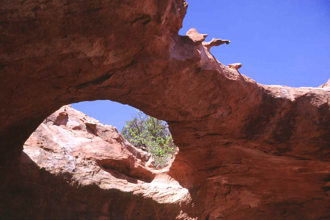
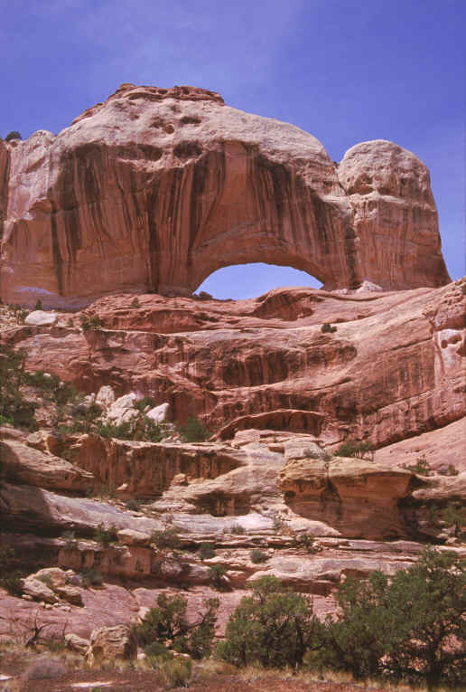
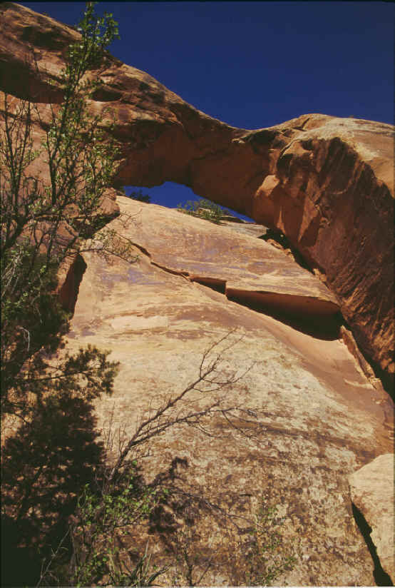
Gargoyle
Arch:
Most of the old-timer members of the NABS were no
longer with the group, for various reasons – some had gotten old, had found
other interests, or had already been to Canyonlands several times, as had I.
So it was almost a whole new group, most of whom didn’t know me either.
I had been with the group ever since their very first convention 20 years
ago, so I have a much longer history with them than even its present president
does; I just hadn’t been to any of the outings in the past 4 years though, so
I had been rather out of touch. I
used to be considered the best photographer of the bunch, and maybe I was!
So now I’ll have to prove it all over again to these newcomers, though
you'd never think so by the pictures on this page -- I had some lousy rolls of
film, and lots of the pictures came out with too much magenta, which was
annoying.
I took off on my own after the hike was over
to look for a nice shady camping spot. You
can’t camp in the Park without paying and staying at their official
campground, and the last thing I want when camping is a bunch of noisy people
around; so I drove for a couple of hours up and down almost every dirt trail for
a dozen miles outside the park boundary on BLM land, till I finally settled on a
secluded spot behind a cliff, which I had to make my own 4-wheel-drive
track to get to.
The next day a big group of us met to do a 4WD trip
through Horse
Canyon
(part of the national park too). I
had driven it twice before, and it’s a magnificent area with several great
arches such as Castle Arch, Fortress Arch, Gothic Arch, and Paul Bunyan’s
Potty (not to mention the nearby Mrs. Bunyan’s Potty too).
But for some reason we only had three 4WD vehicles available – some of
the people had flown in and rented cars, which could never have even begun to
make it through
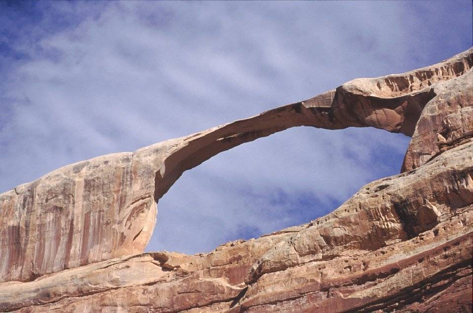
I had been to the glorious Castle Arch twice
before. It involves a bit of a hike,
after driving a couple hours down
Castle
Arch:
Castle
Arch with the split in the span showing:
After that, we all gave up on the horrible 4WD
road, and decided that hiking to the end was more intelligent than tearing up
the trucks. The grand Fortress Arch
is at the end; again I had seen it twice before, but never had managed to get
good pictures, so that was the whole reason I was doing this particular trip
that day. It was still morning light
when we got there, so I finally got some good ones, if overly pinkish.
Marshall
was the only one who tried to hike clear up to the opening.
I had tried years ago and had given up, and so did he.
A technical climber could have managed it, but there was no good reason
for the rest of us to damage ourselves trying – though “bagging” an arch
is always a true arch-hound’s goal; that means going under it, over it, or
through it, preferably all three, though in many cases that is impossible
without flying or falling to one’s death.
So nobody bagged it, but we got close.
On the way out we stopped at several other places, including the
“potty” arches (technically called pothole arches, formed by a hole in the
roof of an alcove that gradually erodes bigger and bigger – an overhead,
somewhat circular arch, in other words. We
also visited the “Thirteen Faces”, a well-known group of Anasazi pictographs
– thousand-year-old Indian art. We
were quite annoyed at the end of the hot, sandy hike to only find 10 faces on
the wall! Not sure why the name, it
didn’t look like there ever were 13 there.
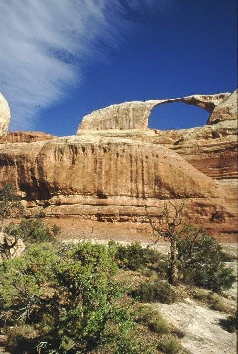
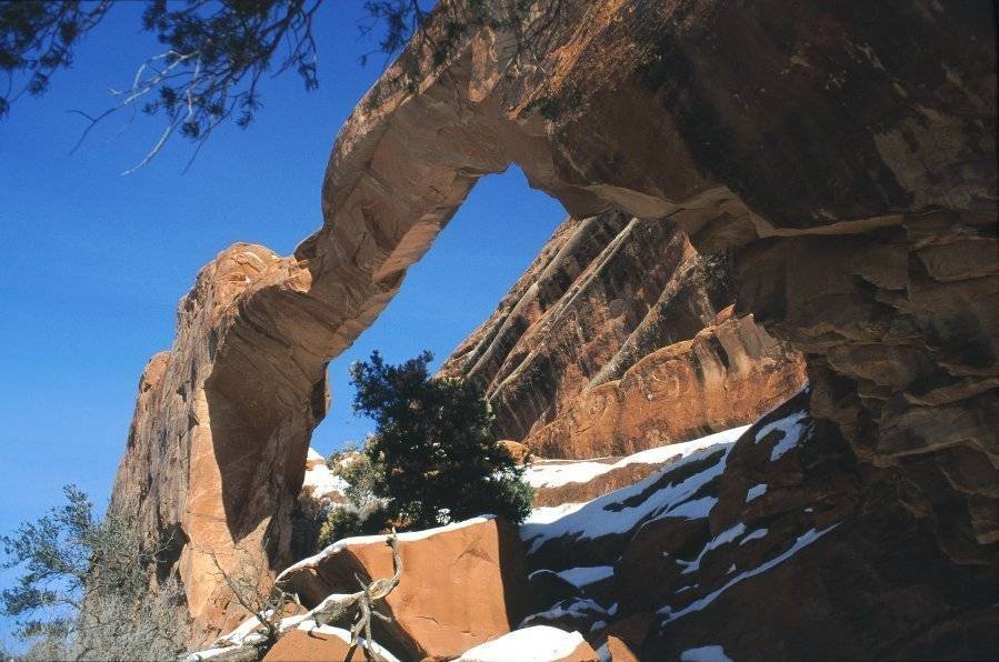
Finally at about
Fortress
Arch:
Paul
Bunyan's Potty:
The next day I woke up tired.
I was signed up for an overnight backpack for that day and the next,
which meant I would have to have 20 or 30 lbs on my back for hours and hours,
which I totally hate, but it’s often necessary, in order to get to distant
arches. I really wanted to see the
newly discovered “Klingon Battle Cruiser Arch”, but that morning I just
couldn’t force myself to get up and go, even though I had packed my backpack
the night before, and had already flinched at the weight, even without a gallon
of water in it. I had to have a
little argument with myself. A
vacation is supposed to be fun! If
you’re not having a good time, if you’re not looking forward to something,
then why do it? One thing I really
didn’t like was the idea that after we got to the arch at 3 or 4 pm
after walking for 6 hours or more, we’d have to put up our tents and then
just sit around until bedtime being bored. No
doubt the others would enjoy visiting and socializing, but of course I would
not, I prefer being a hermit. So I just decided not to go,
and then I felt happy! I spent half
of the day in the back of my truck very contentedly reading a novel, something I
practically never do, but this one was good and informative, and what’s a
vacation for, anyway, if not for relaxing. Besides,
my feet direly needed the rest. Later,
in the afternoon, when the sun was making my campsite too hot, I drove 70 miles
to Moab UT, which is the nearest town of any size, and found a cool shady spot
directly above the Colorado River and beside a cliff, where I read for another
couple of hours. Then at 6:30
I drove to Arches
National Park, but it suddenly got cloudy, so I just turned around.
I was wanting to get a picture of the poor tragic Wall Arch, which
famously collapsed last year of natural causes one dark night after standing for
like 100,000 years. I wanted to take an
“after” picture to go with my several “before” pictures that I had taken
years earlier; but it wasn’t worth the 40-mile drive in and out of the park
and the 2-mile hike plus the entry fee, since the pictures wouldn’t have come
out well anyhow because of the cloudy sky.
A
picture I took of the fallen Wall Arch several years ago:
I went to my favorite City Market grocery store, an
amazing place there in Moab, which has a much better selection of food than
anything I’ve found in all of Oklahoma City, even though OKC is about 500
times bigger than little Moab. Then
it was back to Canyonlands, where I camped in the same place as the first night,
on the faint dirt trail that led behind a desert hill.
The next day I met the group again, or part of it,
thinking we were going to see the Indio Arch and the Brooklyn Arch, neither of
which I knew anything about. The
Indio Arch was very near the road but it took some bushwhacking to get to since
there was no trail, and there was a stream between us and it.
I found a log fallen over the stream, so I and the hike leader went over
it, but the others, who were lagging behind, never seemed to find it.
We got up fairly close to the arch and he took pictures, but I wasn’t
satisfied because I couldn’t see any sky under the arch, it was too close to
the cliff. I kept climbing up closer
to it while he went back to the group, and eventually I got pictures with sky
between the arch and the cliff, which usually makes a better picture.
So I was the only one who did that. Then
going back I couldn’t find the log bridge!
I went the wrong way up the river, then had to backtrack through the
bushes and brush and cactuses, losing a bit of skin and blood along the way.
But nobody cared that I was the straggler, they had all walked over to
see some pictographs on a cliff wall made by the ancient Indians of the area,
the Anasazis, which required a bit of a scramble up a cliff.
In fact, that was what we did for most of the rest of the day, visiting
Indian rock art plus a great cliff dwelling.
We had a picnic in front of an old abandoned mine cut into the rock,
which constantly blew cool air out on us, a welcome thing, since that was the
hottest day of the trip. The biggest
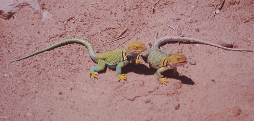
excitement of the day was caused by the discovery of several collared lizards.
I’d never seen one in all my many years of hiking the southwest – but
that day, we found four of them. They
just sat and posed for us till they got bored with us, then they ran away.
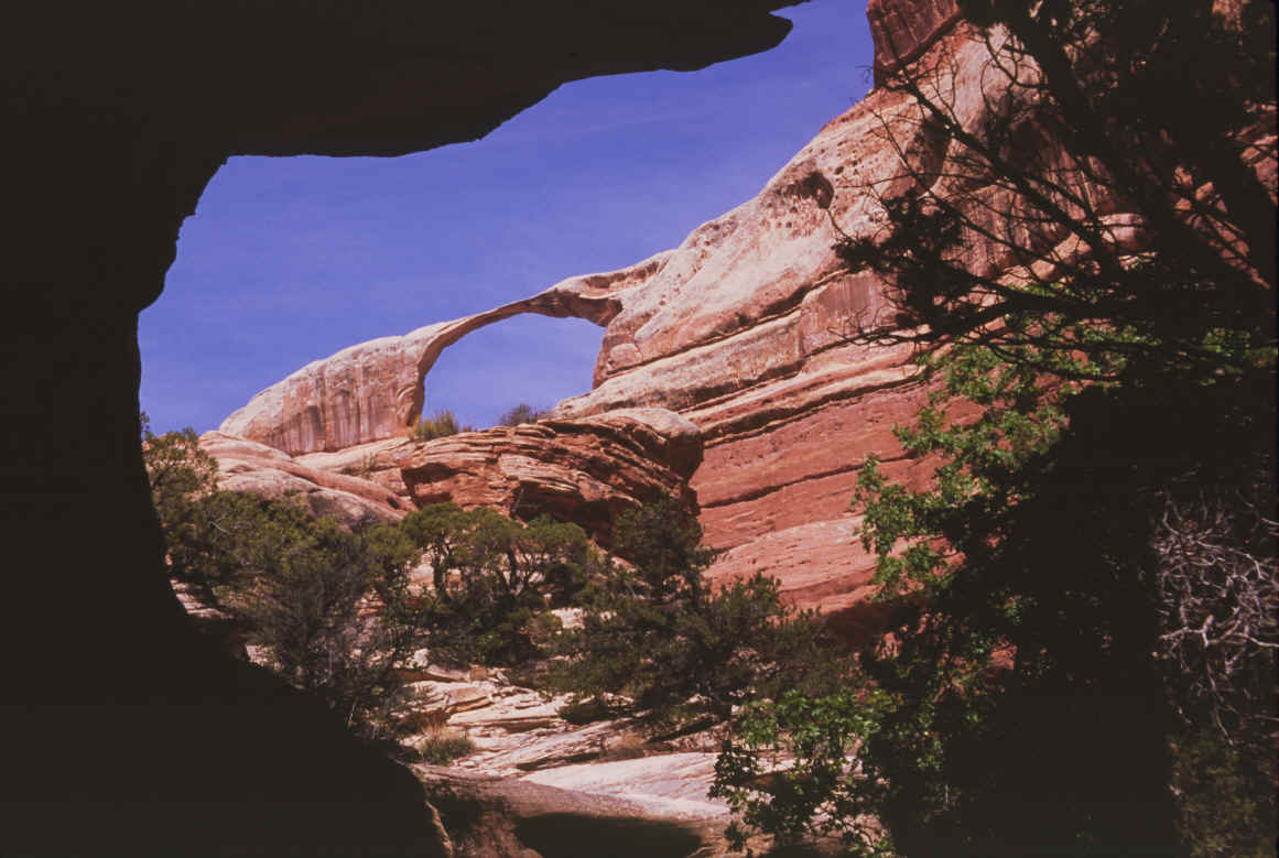
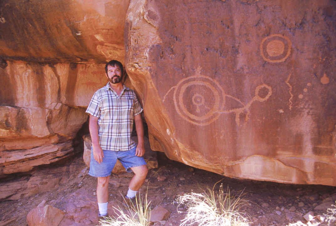
The
Indio Arch:
Ancient
Indian art.... what is it all about?
Nobody knows. Petroglyphs
are carved into the rock. Pictographs
are painted on the rock.
You can see some faint red pictographs behind me.
Collared
lizards:
Then we decided to skip the Brooklyn Arch, since it
was a very long hike and it was hot, and just go 4-wheeling to the Pelican Arch
instead. The arch was not a bit
worth the time and gas and wear on my truck!
It was a dinky little thing, which I guess faintly resembled some
long-billed bird from the back side, but only kind of.
I stayed that night back at my secluded spot not
far from the national park entrance, and did not have a pleasant night!
I had both sliding windows in my camper open a bit, and after an hour of
sleep I suddenly woke up to some really weird scraping sounds on the side of my
truck, like branches were hitting it in the wind, except there were no trees
anywhere around, though there was plenty of wind that night.
It kept on and on, and was a bit scary, because it made no sense…what
was scraping back and forth on my truck?!? Then
suddenly the whole truck shook, like something fell against it!
And still more scraping. All
I could do was lie there and hardly breathe, wondering what on earth was going
on. Finally, I figured it out – it
was only the curtains on the inside of my camper shell brushing against the
screens on the windows! I hardly
ever had had both of them open before on a windy night; and it had only been a
sharp blast of wind that had shaken the whole truck!
I felt dumb, then fell asleep.
The next day would be the hardest hike of my whole
life. Not that I expected it to be
in any way, but it was. In the
morning I joined the group that was going back to Lavender
Canyon, where I had wanted to go the first day but goofed up on.
I should have been suspicious when I realized only the group’s
president and 2 other guys were going. But
I really wanted to see that part of the park.
But it turned out that they were only going to see one particular
distant, hardly ever visited arch called Long Arch.
Since I wasn’t camping each night with the rest of the group, I guess I
wasn’t really as well informed about where we were going each day as they
were. Before we took off, a big
tough-looking park ranger, who I thought was a man until I saw the
lipstick badly smeared all around her mouth, came up to us in her 4-door Jeep
and gave us a 20-minute lecture on the park rules and how to be careful hikers
and what to do and not do, such as not to tear up or steal Indian artifacts and
not to burn wood or destroy native plants… as if we hadn’t all been hiking
the national parks for most of our lives and probably knew the rules better than
she did. Then her punk sidekick,
some kid barely out of forestry school that she was training, felt the need to
repeat to us everything that she had just got through telling us,
only not nearly as well! I was
thinking, he’s so out of shape there’s no way he could even hope to do what
we had been out there doing every day. Yet
here he was lecturing us; so we patiently stood and listened, annoyed.
Finally, we got to take off.
The dirt road to
The hike started out pleasantly enough, for a
couple of miles up a nice side canyon… then the other three guys started going
straight up a cliff wall! Hand over
hand, rock to rock, hour after hour. There
was no sign of a trail, since few in history had ever been silly enough to go to
this place, wherever it was we were heading.
I was of course the straggler again; the other guys all lived in the area
and they did hikes and climbs practically every weekend; then there was poor
low-altitude flatlander Okie me, who did it once a year if even that much.
But I was determined to keep up and not be a wimp, and I wasn’t.
They were very nice guys, and knew it was harder on me, and they were
patient and actually quite proud and complimentary of me and my progress.
The trouble was, they would get quite a ways ahead, then stop to wait for
me. As soon as I caught up, off they
would go again… leaving me thinking, “No fair!
Y’all just got to rest a few minutes while I was catching up and I
didn’t, but I’m the one who needs the rest, and you don’t!”
But I was not about to complain and so that little scenario played out
over and over all day long. Of
course I lost a bit more skin and blood here and there, and dodged a snake once
too. After hours of steady climbing,
over rocks and ledges and exposed scary rims and gravelly dropoffs, we finally
approached what seemed like the top of the canyon… though experience had long ago
taught me that as soon as you think you have finally arrived at the top of some
impossible wall or cliff, that is a sure sign there is much more to be climbed
beyond it that you just can’t quite see – and I was right.
But at long last, we got to the top.
One of the guys had a GPS meter and said we had climbed over 1200 feet,
which may not seem like much but when you’re doing it straight up, on loose
boulders and slickrock ledges, it IS.
They actually didn’t have a clear idea of where they were going, but the meter, which tells latitude and longitude, took us straight to the arch once we got to the canyon rim… but it involved the very annoying and discouraging necessity to drop back down about 300 feet to get to it. One thing any beginning hiker always learns, right off the bat, is never give up any altitude you have gained unless absolutely necessary!! It’s a horrible waste of precious energy to climb way up and over something and then right back down again, when you could have simply gone around it. If you’ve got all the strength in the world and you’re not worried about whether you’ll even make it back to the truck, maybe you can do it, but not usually! Most of the time you want to conserve all the energy you can. But apparently they thought that was the only way to get to Long Arch. This arch sure better be worth it, I thought.
It wasn’t, not
really… it is a pleasant span, not really exceptional, sort of a cliff-hugger
like the Indio arch was, only separated from the cliff wall by a dozen feet or
so, and not really even terribly long. I’m
glad now I went, and proud I did as well as I did, but still, the reward should
have been better than it was! It is
one of the few arches that are actually below you on first view, instead high
above… though it can also be seen from the canyon bottom at certain
viewpoints, which I never saw. So
you’re looking down on the top of it, which means you can’t take pictures
with any sky showing through the opening. Of
course I had to walk out on it. The
other 3 guys didn’t seem too inclined to do so right away, so I was the first
one out. I went to the middle and
saw that going the whole distance was too dangerous, since the other end dipped
quite a ways down, so I turned around and came back.
But I had bagged it, for sure.
It’s weird what the mind does.
If I had walked down a typical sidewalk four or five feet wide somewhere,
no matter how rough it might be, it would never occur to me to feel
scared, to worry about falling, to be afraid a breath of wind might knock me
over, or to be nervous about turning around and going back the opposite way for
fear of losing my balance; I could prance and cavort on that lumpy sidewalk all
day without a problem. So why is it
that when one is on top of an arch of the same width, that one is totally
stricken with terror and practically frozen with petrifying fear, merely because
there is a dropoff of over 1000 feet on each side of you leading to sure and
instant bouncing death? It makes no
sense! Or maybe it does?
Keeps you from doing anything silly, at least.
One of the guys with me there told of his friend who did a handstand on
top of the incredibly fragile and narrow Ribbon Arch in Arches National Park,
hardly half as wide as the Long Arch… now that was crazy!
But amazing. I didn’t
attempt it on this one.
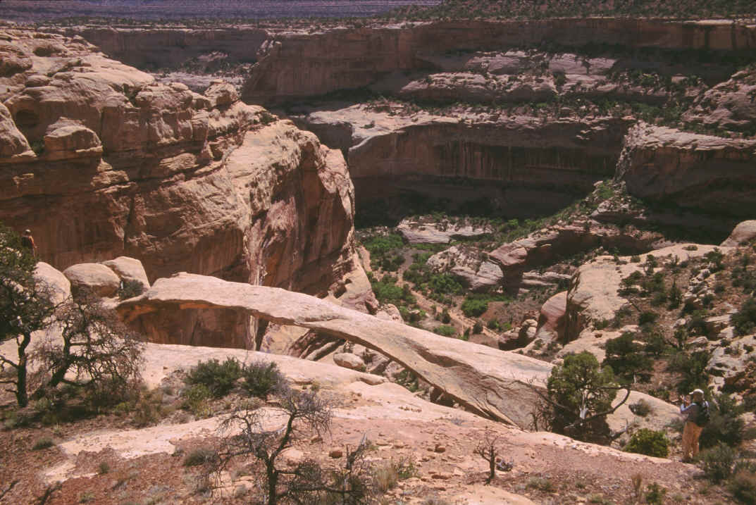
Long
Arch:
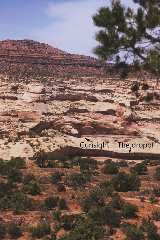
After we had our lunch up there, the leader,
looking at a map, noticed that the big Gunsight Arch was only a mile and a half
away, “as the crow flies”. Why
not go see it while we were up there? The
other guys weren’t too sure, they were I think more tired than they were
trying to show. They left it up to
me! Actually, I had always wanted to
see it, it’s one of the truly great arches in Canyonlands, and one that hardly
anybody has been up close to. So I
said sure, why not! So off we went.
No one knew where it was, they were just following the topo map, which
are notoriously inaccurate when pinpointing features like arches.
But eventually, after crossing a high plateau, clear off on the rim of
another canyon which turned out to be the upper reaches of
Since they were holding
the map, they already knew what I couldn’t see – that right below the
Gunsight Arch was a 1000-foot dropoff… practically invisible to us where we
were standing, on a ridge clear across the valley, but very apparent on the map.
Impossible, in other words. The
only way to do it would be to travel clear around the end of Davis Canyon, then
back around the other side, which might or might not be possible, who knew…
and might or might not take us over to the arch.
So I said, well, I guess we better not, because we’d still have to come
all the way back, with no assurance of success anyhow.
They seemed greatly relieved. But
I got some distant shots of the great Gunsight, which I may never see again.
Gunsight
Arch, from a long ways away:
Then we had the hike back down!
Or rather, 300 feet back up, over the ridge, then back down those
1200 feet. Why is going down just
about as hard as going up? It puts a
totally different strain on the legs than climbing does, and actually jars them
much worse, since your whole weight is actually falling on your feet and knees
with each step more heavily than it normally would on flat ground, or while
going up. And this involved almost
as much use of the arms and hands as it did the feet, too… constantly pushing
off from or swinging from rock to rock, trying to take as much weight off from
the feet as possible. Having 10 lbs
of water strapped around one’s waist doesn’t make thing easier, but you’d
sure die without it… it was after all another hot day out there, approaching
90°. I was glad the other guys sort of were
in command, because I had just been following on the way up and not particularly
memorizing the way, such as there was; but after a few false starts and dead
ends, they seemed on the right track going back down, though we were still
winging it part of the time and sometimes every one of us was going down a
different part of the cliff face, whatever seemed easiest to us at the moment;
as long as we eventually got to the bottom and didn’t hit an impossible
dropoff was all that mattered. All
the way down, which seemed interminable, I was thinking, “I cannot believe we
actually climbed all this way UP while ago!”
But in the morning, we had had lots more energy and cooler weather; doing
it the other way around would have been a real killer.
After all, we had climbed almost the exact height of the Empire