
I seem to belong to a rare group of idiots known as arch hounds. We are people who hike around out in the deserts and canyons and mountains and boondocks of the Southwest looking for those great natural arches and bridges that rain and rivers have carved from the rock. I say "we", though I’ve never met any others yet, but I guess there are some because there is a set of guide books written for us telling where to find the best arches, which atrocious dirt roads we have to take to get there, and how many miles of hiking over gorge and gully we have to do in the hopes of finding the things. And since the books were written years ago, the directions don’t necessarily reflect the way things really are out there any more.
Having failed to find copies of the books anywhere in San Francisco or Los Angeles, one day I finally discovered a few volumes in the Phoenix library. They were just paperbacks, Readers Digest size, the text evidently done on somebody’s old typewriter with a few dismal black and white photos Xeroxed in; but for three days I studied them there, studied maps and topography charts, and copied pages and pages of instructions and directions to take with me. I decided to go see a certain Royal Arch in the Navajo reservation far out in the outback behind a place called Cove, Arizona.
Long ago I had discovered such glorious places as Arches National Park and the Canyonlands in Utah, and decided that that area was my favorite place in the universe. Several times I’d been back to see them, the greatest collection of arches on earth. But they have sidewalks there, and guard rails, and parking lots, restrooms, garbage cans, picnic tables, and signs all over saying do this and don’t do that, which is all very well and necessary for the droves of tourists driving through. But I wanted to see the arches out in the wilds, like the ancient Indians saw them, arches the way they were designed to be seen, as part of untamed nature, alone in nature.
Often across the country I had seen great views, magnificent scenery, awesome sights, but just about always the hand of man was present too -- here a road, there a house, a power line, water tower, or a jet track in the sky. But I wanted scenery like it used to be. And also, who can look at a great natural arch ten stories tall and not want to climb up and over it? Actually I guess a lot of people can, some of them look pretty terrifying, narrow and windy on top. But I always wanted to try it if it looked at all possible. You just don’t do that in Arches National Park though, no way, you’d get arrested. So I was going out to look for wild arches, untamed by tourists and park rangers.
I had spent the morning hiking down in the Canyon de Chelly, outside of Chinle, Arizona, and figured that in the afternoon I’d drive up to Cove, see the Royal Arch, and perhaps get back in time to find the beautiful Hope Arch close to Chinle. Yeah, sure! Little did I know.
On the map the roads looked innocent enough. I was to go from Chinle to Lukachukai, take Highway 13 to Red Rock, then a ten-mile dirt road to Cove and another small dirt road to the arch. From there I could either go back to Chinle via Highway 13, or go on to Highway 666 in New Mexico. Except for those rather ominous-looking highway numbers, it looked easy. I really had no business doing any back-country exploring in my beat-up old camper van. But I was going to try.
I had no problem getting out to Lukachukai, but there a couple of Indians told me that the road to Red Rock was closed two days ago because of flooding. I didn’t see any "closed" signs now, so I started on my way. Soon the road, grandly termed "Navajo Nation Highway 13" on the map, fizzled down to a mere two dirt tracks, with great ditches and drop-offs alongside, between, and all to often, across them.
I was going past some of the most glorious scenery in the whole Southwest, but the road appeared to be heading straight for a wall of mountains. Am I going over that?! Evidently so -- the road started going straight up, and my poor old van with its little rubber-band engine started grunting and wheezing and straining, not to mention sliding around quite a bit.
Part way up I came across a big red 4-wheel-drive pickup facing downhill with two wheels stuck in a ditch; hopeless, it was nearly tipped over on its side. Three Indian boys asked me if I had a shovel, which I didn’t, so they lost all interest in me, but I couldn’t get on around them and their stuck truck. Soon another truck came downhill and stopped (he couldn’t get around either). He had a rope and an ancient Navajo grandpa with him who had plenty of opinions about how to go about doing the whole procedure, and since nobody would listen to him, he came over and expounded it all to me at great length. In Navajo. Presently they moved the truck a bit and I could squeeze on by, but it was still as stuck as ever. I asked the boys if the rest of the road ahead was passable for my old van. They were rather surly, understandably so, but said yeah, probably, but it was all about like this part, meaning it was terrible. Not too reassuring! And since I had heard that the Navajos don’t take too kindly to white people wandering around through their reservation lands anyhow, for all I knew they were just saying that so they could snicker at me as I took off uphill to sure disaster.
But an hour later, I actually got to the top of the mountain range, and stopped a while. An Indian man who had just come up the other side was there, letting his car cool down, and told me the road was drivable the rest of the way. He said it split off in a few different directions, so he drew me out in great detail a map of how to get on down, and where he lived, and where he used to live, and where his cousins lived, and where the best fishing holes were. He told me four times how to get to the fishing holes. He also noticed I had a little leak under my van, and smelled it -- radiator water. It wasn’t running hot though, but a little way on down I stopped at a spring (he had drawn it on his map too) and poured in some more water.
Finally I was out of the mountains. It had taken me over 2 hours to go 7 miles. Then the road was paved for a bit, but soon I came to the turnoff for Cove -- a ten-mile dirt road out to the few houses that make up the town. At least this road was wide and flat, though awfully washboardy. Eventually I came to a sign pointing to the Navajo Chapter House for Cove, up a side road on a hilltop.
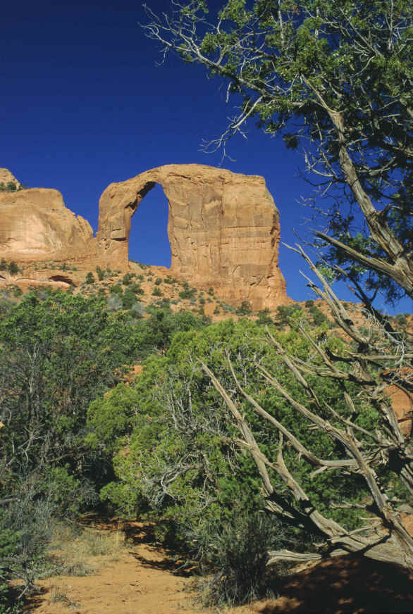
I had been told I should go to the chapter house, whatever that was, to ask for permission to go hike out on the tribal lands. It was already nearly 5 o’clock, and after coming all that perilous way across the mountains I wasn’t about to risk having them tell me no, you can’t go out there. So I just drove on past. I could see the arch way off in the distance anyway, on the skyline, so I headed towards it. The directions said I would have to take a certain dirt road out beyond the last house to get there: "The road is bad and gets worse as you go along." You don’t say! This one made Highway 13 look grand. The ruts were so deep my engine was dragging the ground and I had to go so slow the speedometer usually read "0".
I came up to a barbwire gap across the road, with no signs, just two poles standing alongside the track with old tires hanging from them. What was that supposed to mean? Was it some dire warning? Some ancient Navajo danger symbol? If so, I’d come too far to turn back, so I opened the gap, closed it behind me, and went on, worrying mightily that a troupe of angry Indians could at any time come swarming out in their big red pickups (they all seem to have big red 4-wheel-drive pickups, which means they are smarter than I am) and I’d be sort of defenseless. For all I knew, this might be sacred territory and I was desecrating it by being a white kid; maybe this was some great holy arch, venerated by their ancestors for countless millennia. After all, it was shaped like a giant church window, like a gothic arch -- no, I guess that was a stupid correlation; but I was nervous.